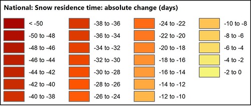
Absolute change in snow residence time (CONUS) (Image Service)
The National Forest Climate Change Maps project was developed by the Rocky Mountain Research Station (RMRS) and the Office of Sustainability and Climate to meet the needs of national forest managers for information on projected climate changes at a scale relevant to decision making processes, including forest plans. The maps use state-of-the-art science and are available for every national forest in the contiguous United States with relevant data coverage. Currently, the map sets include variables related to precipitation, air temperature, snow (including snow residence time and April 1 snow water equivalent), and stream flow.
\n\n
Snow residence time (in days) and April 1 snow water equivalent (in mm) were modeled using the spatial analog models of Luce et al., 2014 (https://agupubs.onlinelibrary.wiley.com/doi/full/10.1002/2013WR014844); see also Lute and Luce, 2017 (https://agupubs.onlinelibrary.wiley.com/doi/full/10.1002/2017WR020752). These models are built on precipitation and snow data from Snowpack Telemetry (SNOTEL) stations across the western United States and temperature data from the TopoWx dataset (https://rmets.onlinelibrary.wiley.com/doi/10.1002/joc.4127). They were calculated for the historical (1975-2005) and future (2071-2090) time periods, along with absolute and percent change.
\n\n
Raster data are also available for download from RMRS site (https://www.fs.usda.gov/rm/boise/AWAE/projects/NFS-regional-climate-change-maps/categories/us-raster-layers.html), along with pdf maps and detailed metadata (https://www.fs.usda.gov/rm/boise/AWAE/projects/NFS-regional-climate-change-maps/downloads/NationalForestClimateChangeMapsMetadata.pdf).They were calculated for the historical (1975-2005) and future (2071-2090) time periods, along with absolute and percent change.
Data and Resources
| Field | Value |
|---|---|
| accessLevel | public |
| bureauCode | {005:96} |
| catalog_@context | https://project-open-data.cio.gov/v1.1/schema/catalog.jsonld |
| catalog_conformsTo | https://project-open-data.cio.gov/v1.1/schema |
| catalog_describedBy | https://project-open-data.cio.gov/v1.1/schema/catalog.json |
| identifier | https://www.arcgis.com/home/item.html?id=f4119d1123ed41948a924c39a6c5960b |
| issued | 2017-11-22 |
| landingPage | https://data-usfs.hub.arcgis.com/datasets/usfs::absolute-change-in-snow-residence-time-conus-image-service |
| license | https://creativecommons.org/licenses/by/4.0/ |
| metadata_type | geospatial |
| modified | 2022-08-25 |
| old-spatial | -134.9134,21.0830,-56.9007,52.3709 |
| programCode | {005:059} |
| progressCode | onGoing |
| publisher | U.S. Forest Service |
| resource-type | Dataset |
| source_datajson_identifier | true |
| source_hash | 7592f98616fea9c326baba03a7a33ba4c708b48a4ed873ed828a63ed27bdff13 |
| source_schema_version | 1.1 |
| spatial | {"type": "Polygon", "coordinates": [[[-134.9134, 21.0830], [-134.9134, 52.3709], [-56.9007, 52.3709], [-56.9007, 21.0830], [-134.9134, 21.0830]]]} |
| theme | {geospatial} |
| Groups |
|
| Tags |
|
| isopen | True |
| license_id | cc-by |
| license_title | Creative Commons Attribution |
| license_url | http://www.opendefinition.org/licenses/cc-by |
| maintainer | USFSEnterpriseContent |
| maintainer_email | SM.FS.data@usda.gov |
| metadata_created | 2025-09-24T05:51:12.129994 |
| metadata_modified | 2025-09-24T05:51:12.130003 |
| notes | <p>The National Forest Climate Change Maps project was developed by the Rocky Mountain Research Station (RMRS) and the Office of Sustainability and Climate to meet the needs of national forest managers for information on projected climate changes at a scale relevant to decision making processes, including forest plans. The maps use state-of-the-art science and are available for every national forest in the contiguous United States with relevant data coverage. Currently, the map sets include variables related to precipitation, air temperature, snow (including snow residence time and April 1 snow water equivalent), and stream flow.</p>\n\n<p>Snow residence time (in days) and April 1 snow water equivalent (in mm) were modeled using the spatial analog models of Luce et al., 2014 (https://agupubs.onlinelibrary.wiley.com/doi/full/10.1002/2013WR014844); see also Lute and Luce, 2017 (https://agupubs.onlinelibrary.wiley.com/doi/full/10.1002/2017WR020752). These models are built on precipitation and snow data from Snowpack Telemetry (SNOTEL) stations across the western United States and temperature data from the TopoWx dataset (https://rmets.onlinelibrary.wiley.com/doi/10.1002/joc.4127). They were calculated for the historical (1975-2005) and future (2071-2090) time periods, along with absolute and percent change.</p>\n\n<p>Raster data are also available for download from RMRS site (https://www.fs.usda.gov/rm/boise/AWAE/projects/NFS-regional-climate-change-maps/categories/us-raster-layers.html), along with pdf maps and detailed metadata (https://www.fs.usda.gov/rm/boise/AWAE/projects/NFS-regional-climate-change-maps/downloads/NationalForestClimateChangeMapsMetadata.pdf).They were calculated for the historical (1975-2005) and future (2071-2090) time periods, along with absolute and percent change.</p><p><img alt='Legend' src='https://farm8.staticflickr.com/7904/47007969091_dfff1b867d.jpg' /><br /></p> |
| num_resources | 3 |
| num_tags | 25 |
| title | Absolute change in snow residence time (CONUS) (Image Service) |