Regrid USA Nationwide Parcel Boundaries
Open Regrid's Parcel Tile Layer
As Esri’s commercial partner for parcel data, Regrid invites you to enjoy this free tile layer of parcel boundaries covering 100% of the United States. Complete parcel attributes are also available from an integrated Data Store.
"I think it’s fantastic that this layer exists. It's really helpful for my staff to see parcel boundaries in a quick and accessible layer."
- Kate Berg, GIS Manager | Department of Environment, Great Lakes, and Energy
Hassle-free parcel data for Esri Users
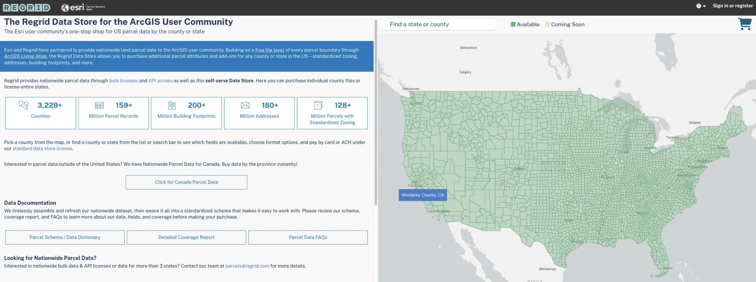
When you click a parcel in the tile layer, you will see its address, size, and parcel ID number, along with a convenient link to purchase additional parcel attributes in the Regrid Data Store for the ArcGIS User Community.
Once in the Data Store, you can purchase and download parcel files with attributes by the county and state for use in ArcGIS, as well as our add-on datasets like standardized zoning, matched building footprints, and matched secondary addresses.
Key features of Regrid's parcel data
Sourced and standardized: Data combines authoritative public sources & third-party enrichments, aggregated, standardized, and matched by the Regrid team.
158+ million parcel records: Covering all 3,200+ US counties and territories.
143+ standardized data fields: Including geometry, ownership, buildings, secondary addresses, land use, and zoning.
Universal parcel ID and placekey location identifier: Ensuring precise identification and integration.
Detailed attributes: Tax assessments, building counts, square footage, stacked parcels (condos), right-of-way, vacancy indicators and USPS deliverability.
Comprehensive coverage: 100% land parcel coverage across the US.
Visit Regrid.com/Esri to browse our portfolio of parcel products for the Esri ecosystem, including Feature Service delivery for ongoing parcel updates at scale.
Explore all Regrid's offerings for Esri customers
Parcel data resources and documentation
Thank you to all the GIS professionals, state, county and federal officials, assessors, recorders, and public officials across the country who maintain the nation's parcel data and infrastructure.
Data and Resources
| Field | Value |
|---|---|
| dcat_issued | 2024-06-20T14:04:10.000Z |
| dcat_modified | 2026-07-28T14:46:03.000Z |
| dcat_publisher_name | Regrid |
| guid | https://www.arcgis.com/home/item.html?id=a2050b09baff493aa4ad7848ba2fac00&sublayer=0 |
| Tags |
|
| isopen | False |
| metadata_created | 2025-09-19T01:27:14.297704 |
| metadata_modified | 2026-08-19T15:27:29.185960 |
| notes | <p style='text-align:center;'><a target='_blank' href='https://www.arcgis.com/apps/mapviewer/index.html?layers=a2050b09baff493aa4ad7848ba2fac00' rel='nofollow ugc noopener noreferrer'><span style='color:#4169e1; font-size:42px;'><strong><u>Open Regrid's Parcel Tile Layer</u></strong></span></a></p><p style='line-height:1.38; margin-bottom:0pt; margin-top:0pt;'> </p><p style='line-height:1.38; margin-bottom:0pt; margin-top:0pt;'><span style='font-family:Arial, sans-serif; font-size:large;'><span style='font-variant-alternates:normal; font-variant-east-asian:normal; font-variant-numeric:normal; font-variant-position:normal;'>As Esri’s commercial partner for parcel data, </span></span><a target='_blank' href='https://regrid.com/' rel='nofollow ugc noopener noreferrer'><span style='color:#4169e1; font-family:Arial, sans-serif; font-size:large;'><span style='font-variant-alternates:normal; font-variant-east-asian:normal; font-variant-numeric:normal; font-variant-position:normal;'><strong><u>Regrid</u></strong></span></span></a><span style='font-family:Arial, sans-serif; font-size:large;'><span style='font-variant-alternates:normal; font-variant-east-asian:normal; font-variant-numeric:normal; font-variant-position:normal;'> invites you to enjoy this free tile layer of parcel boundaries covering 100% of the United States. Complete parcel attributes are also available from an integrated Data Store.</span></span></p><p style='line-height:1.38; margin-bottom:0pt; margin-top:0pt;'> </p><p style='line-height:1.38; margin-bottom:0pt; margin-left:40px; margin-top:0pt;'><span style='font-family:Arial, sans-serif; font-size:18px;'><i><span style='font-variant-alternates:normal; font-variant-east-asian:normal; font-variant-numeric:normal; font-variant-position:normal;'><strong>"I think it’s fantastic that this layer exists. It's really helpful for my staff to see parcel boundaries in a quick and accessible layer."</strong></span></i></span></p><p style='line-height:1.38; margin-bottom:0pt; margin-left:80px; margin-top:0pt;'><span style='background-color:rgb(255,255,255); font-family:Arial, sans-serif; font-size:14px;'><span style='font-variant-alternates:normal; font-variant-east-asian:normal; font-variant-numeric:normal; font-variant-position:normal;'>- </span><span>Kate Berg, GIS Manager | </span></span><span style='font-family:Arial, sans-serif; font-size:14px;'><span>Department of Environment, Great Lakes, and Energy</span></span></p><p style='line-height:1.38; margin-bottom:0pt; margin-top:0pt;'> </p><p style='line-height:1.38; margin-bottom:0pt; margin-top:0pt;'> </p><p style='line-height:1.38; margin-bottom:0pt; margin-top:0pt;'><span style='background-color:rgb(255,255,255); color:#2f4f4f; font-family:Arial, sans-serif; font-size:32px;'><span style='font-style:normal; font-variant:normal; text-decoration:none;'><strong>Hassle-free parcel data for Esri Users</strong></span></span></p><p style='line-height:1.38; margin-bottom:0pt; margin-top:0pt;'> </p><p style='line-height:1.38; margin-bottom:0pt; margin-top:0pt;'><span style='background-color:#ffffff; color:#4c4c4c; font-family:Arial,sans-serif; font-size:12pt;'><span style='font-style:normal; font-variant:normal; font-weight:400; text-decoration:none;'>When you click a parcel in the tile layer, you will see its address, size, and parcel ID number, along with a convenient link to purchase additional parcel attributes in the </span></span><a target='_blank' href='https://app.regrid.com/store/esri?source=la-details' rel='nofollow ugc noopener noreferrer'><span style='color:#4169e1; font-size:18px;'><strong><u>Regrid Data Store for the ArcGIS User Community</u></strong></span></a><span style='background-color:rgb(255,255,255); color:rgb(76,76,76); font-family:Arial, sans-serif; font-size:12pt;'><span style='font-style:normal; font-variant:normal; text-decoration:none;'><strong>. </strong></span></span><br /><br /><span style='background-color:#ffffff; color:#4c4c4c; font-family:Arial,sans-serif; font-size:12pt;'><span style='font-style:normal; font-variant:normal; font-weight:400; text-decoration:none;'>Once in the Data Store, you can purchase and download parcel files with attributes by the county and state for use in ArcGIS, as well as our add-on datasets like standardized zoning, matched building footprints, and matched secondary addresses.</span></span></p><p style='line-height:1.38; margin-bottom:0pt; margin-top:0pt;'> </p><figure><p><a target='_blank' href='https://app.regrid.com/store/esri?source=la-details' rel='nofollow ugc noopener noreferrer'><img src='https://9363140.fs1.hubspotusercontent-na1.net/hubfs/9363140/living-atlas-regrid-02022026.png' width='2476' height='926' /></a></p></figure><p style='line-height:1.38; margin-bottom:0pt; margin-top:0pt; padding:0pt;'> </p><p style='line-height:1.38; margin-bottom:0pt; margin-top:0pt; padding:0pt;'><span style='color:#000000; font-family:Arial, sans-serif; font-size:x-large;'><strong>Key features of Regrid's parcel data</strong></span></p><ul><li><p style='background-color:#ffffff; line-height:1.7999999999999998; margin-bottom:0pt; margin-top:15pt;'><span style='background-color:#ffffff; color:#4c4c4c; font-family:Arial,sans-serif; font-size:12pt;'><span style='font-style:normal; font-variant:normal; text-decoration:none;'><strong>Sourced and standardized: </strong></span><span style='font-style:normal; font-variant:normal; font-weight:400; text-decoration:none;'>Data combines authoritative public sources & third-party enrichments, aggregated, standardized, and matched by the Regrid team.</span></span></p></li><li><p style='background-color:#ffffff; line-height:1.7999999999999998; margin-bottom:0pt; margin-top:0pt;'><span style='background-color:#ffffff; color:#4c4c4c; font-family:Arial,sans-serif; font-size:12pt;'><span style='font-style:normal; font-variant:normal; text-decoration:none;'><strong>158+ million parcel records: </strong></span><span style='font-style:normal; font-variant:normal; font-weight:400; text-decoration:none;'>Covering all 3,200+ US counties and territories.</span></span></p></li><li><p style='background-color:#ffffff; line-height:1.7999999999999998; margin-bottom:0pt; margin-top:0pt;'><span style='background-color:#ffffff; color:#4c4c4c; font-family:Arial,sans-serif; font-size:12pt;'><span style='font-style:normal; font-variant:normal; text-decoration:none;'><strong>143+ standardized data fields:</strong></span><span style='font-style:normal; font-variant:normal; font-weight:400; text-decoration:none;'> Including geometry, ownership, buildings, secondary addresses, land use, and zoning.</span></span></p></li><li><p style='background-color:#ffffff; line-height:1.7999999999999998; margin-bottom:0pt; margin-top:0pt;'><span style='background-color:#ffffff; color:#4c4c4c; font-family:Arial,sans-serif; font-size:12pt;'><span style='font-style:normal; font-variant:normal; text-decoration:none;'><strong>Universal parcel ID and placekey location identifier: </strong></span><span style='font-style:normal; font-variant:normal; font-weight:400; text-decoration:none;'>Ensuring precise identification and integration.</span></span></p></li><li><p style='background-color:#ffffff; line-height:1.7999999999999998; margin-bottom:0pt; margin-top:0pt;'><span style='background-color:#ffffff; color:#4c4c4c; font-family:Arial,sans-serif; font-size:12pt;'><span style='font-style:normal; font-variant:normal; text-decoration:none;'><strong>Detailed attributes: </strong></span><span style='font-style:normal; font-variant:normal; font-weight:400; text-decoration:none;'>Tax assessments, building counts, square footage, stacked parcels (condos), right-of-way, vacancy indicators and USPS deliverability. </span></span></p></li><li><p style='background-color:#ffffff; line-height:1.7999999999999998; margin-bottom:11pt; margin-top:0pt;'><span style='background-color:#ffffff; color:#4c4c4c; font-family:Arial,sans-serif; font-size:12pt;'><span style='font-style:normal; font-variant:normal; text-decoration:none;'><strong>Comprehensive coverage: </strong></span><span style='font-style:normal; font-variant:normal; font-weight:400; text-decoration:none;'>100% land parcel coverage across the US.</span></span> </p></li></ul><p style='line-height:1.38; margin-bottom:17pt; margin-top:0pt;'><br /><span style='background-color:rgb(255,255,255); color:rgb(76,76,76); font-family:Arial, sans-serif; font-size:12pt;'><span style='font-style:normal; font-variant:normal; text-decoration:none;'>Visit </span></span><a target='_blank' href='https://regrid.com/' rel='nofollow ugc noopener noreferrer'><span style='background-color:rgb(255,255,255); color:#4169e1; font-family:Arial, sans-serif; font-size:12pt;'><span style='font-style:normal; font-variant:normal; text-decoration:none;'><strong><u>Regrid.com/Esri</u></strong></span></span></a><span style='background-color:rgb(255,255,255); color:rgb(76,76,76); font-family:Arial, sans-serif; font-size:12pt;'><span style='font-style:normal; font-variant:normal; text-decoration:none;'> to browse our portfolio of parcel products for the Esri ecosystem, including Feature Service delivery for ongoing parcel updates at scale. </span></span></p><p style='line-height:1.38; margin-bottom:17pt; margin-top:0pt; text-align:center;'> </p><p style='line-height:1.38; margin-bottom:17pt; margin-top:0pt; text-align:center;'><a target='_blank' href='https://regrid.com/esri' rel='nofollow ugc noopener noreferrer'><span style='color:#4169e1; font-size:36px;'><strong><u>Explore all Regrid's offerings for Esri customers</u></strong></span></a></p><p style='line-height:1.38; margin-bottom:17pt; margin-top:0pt;'> </p><p style='line-height:1.38; margin-bottom:17pt; margin-top:0pt;'><span style='color:#000000; font-family:Arial, sans-serif; font-size:x-large;'><strong>Parcel data resources and documentation</strong></span></p><ul><li><p style='line-height:1.7999999999999998; margin-bottom:0pt; margin-top:15pt;'><a style='text-decoration:none;' target='_blank' href='https://hubs.li/Q02F6p8G0' rel='nofollow ugc noopener noreferrer'><span style='background-color:#ffffff; color:#4169e1; font-family:Arial,sans-serif; font-size:12pt;'><span style='font-style:normal; font-variant:normal; text-decoration:none;'><strong><u>Regrid data dictionary and parcel data schema</u></strong></span></span></a></p></li><li><p style='line-height:1.7999999999999998; margin-bottom:0pt; margin-top:0pt;'><a style='text-decoration:none;' target='_blank' href='https://hubs.li/Q02F6r780' rel='nofollow ugc noopener noreferrer'><span style='background-color:#ffffff; color:#4169e1; font-family:Arial,sans-serif; font-size:12pt;'><span style='font-style:normal; font-variant:normal; text-decoration:none;'><strong><u>Regrid coverage report</u></strong></span></span></a></p></li><li><p style='line-height:1.7999999999999998; margin-bottom:11pt; margin-top:0pt;'><a style='text-decoration:none;' target='_blank' href='https://hubs.li/Q02F6sVf0' rel='nofollow ugc noopener noreferrer'><span style='background-color:#ffffff; color:#4169e1; font-family:Arial,sans-serif; font-size:12pt;'><span style='font-style:normal; font-variant:normal; text-decoration:none;'><strong><u>Parcel data FAQs</u></strong></span></span></a></p></li></ul><div><div><br /> </div><div><span style='font-size:14px;'><i>Thank you to all the GIS professionals, state, county and federal officials, assessors, recorders, and public officials across the country who maintain the nation's parcel data and infrastructure.</i></span></div></div> |
| num_resources | 2 |
| num_tags | 90 |
| title | Regrid USA Nationwide Parcel Boundaries |
| url | https://prep-response-portal.napsgfoundation.org/datasets/regrid::regrid-usa-nationwide-parcel-boundaries |